Preliminary design of data testing for physical accounts of terrestrial ecosystems in Armenia (initiated and carrying out by BCC Armenia in 2023)
1. Ecosystem extent and condition in Armenia
At the first stage of the project data testing uses available digital map of vegetation/landscapes and current land cover (specific resources will be selected later in consultation with project experts). Current land cover will give basic estimates for few land cover types. A map of current ecosystems obtained by combination of maps of vegetation/landscapes and current landcover, will give more detailed estimates which are useful for planning of biodiversity protection.
Other data may also be used at further stages of the project.
Data testing scheme for ecosystem extent and condition is shown below.

Current area of main land cover types (forest, grasslands, wetlands, crops, built-up areas) in the whole Armenia, in the marzes (regions) of Armenia, and in the municipalities – can be defined by available land cover. Our previous experience shows that inaccuracies in determining areas of land cover types may be associated primarily with the separation of grasslands and croplands.
Dynamics of areas of land cover types can be also determined by regularly updated land covers. Some of them already make it possible to determine the previous dynamics over several years.
A more detailed assessment for the purposes of conserving the ecosystem diversity of Armenia can be made by combining a vegetation map and an actual land cover. The intersection of these maps will allow us to track changes in the area of all types of ecosystems identified on the vegetation map
At further stages of the formation of ecosystem accounting, the areas of land types can also be clarified by Public Cadaster Map of Armenia
– Fragmentation/connectivity of ecosystems can be assessed already at the first stage of the project based on the current landcover.
– Current land/soil pollution and sources of pollution (future stages).
– The degree of soil erosion (further stages).
– Data on species diversity are useful for assessment of cultural informational ecosystem services (see below). Species diversity in itself is not an indicator of the condition of ecosystems and their conservation value, since different ecosystems typically have different diversity (see here). Obvious indicators are only trends in changes in these indicators – their deterioration or improvement.
– Data on Red Data Book species can be used for assessing trends of ecosystem condition if they will include both data if they include both species registration data and the length of the observation route.
3. Ecosystem services
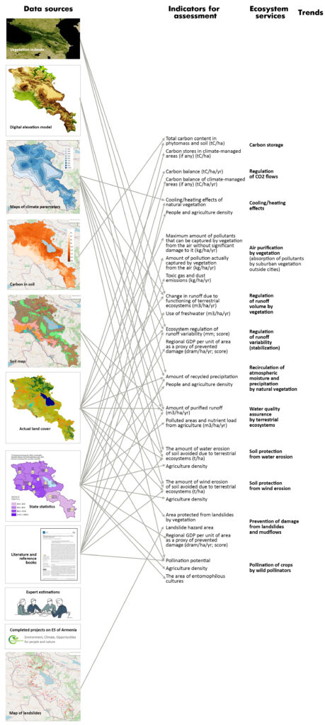
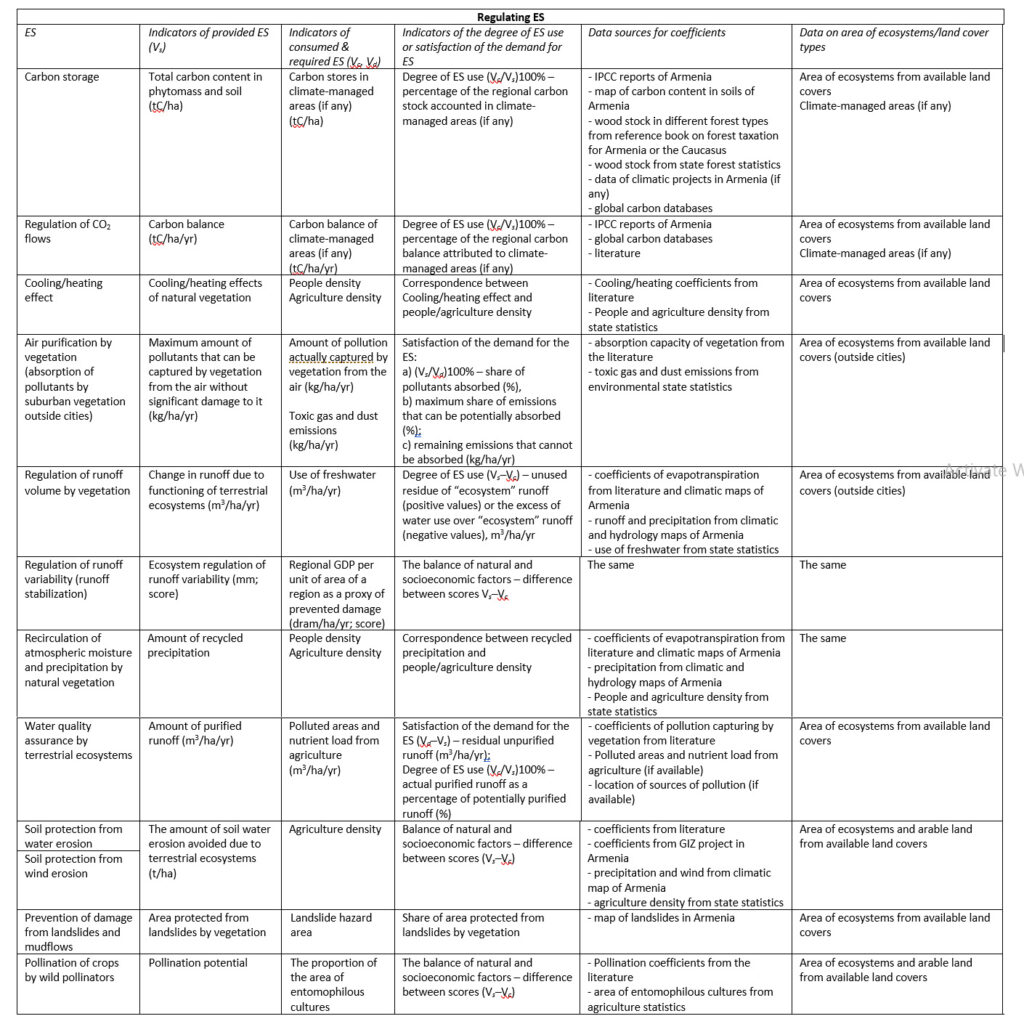
Regulating ES provide good conditions for provisioning ES, for agriculture, and for recreation. Regulating ES related to atmosphere, soil and water are closely connected between each other. For example, preventing water and wind erosion of soils simultaneously ensures the quality of surface runoff and air quality, reducing the amount of dust. These relationships facilitate physical valuation of ES, since the same indicators and maps can be used to evaluate different services. When monetary valuing, this must be taken into account to avoid double counting.

An example of the interaction of soil-protective and water-regulating services performed by vegetation: on the right, the site is protected from overgrazing, has developed grass and soil covers, which also retain water, allowing woody vegetation to develop there as well. On the left, the site is almost devoid of vegetation and soil and is being dried out (neighborhood of Yerevan, Kasakh village, January 2023).

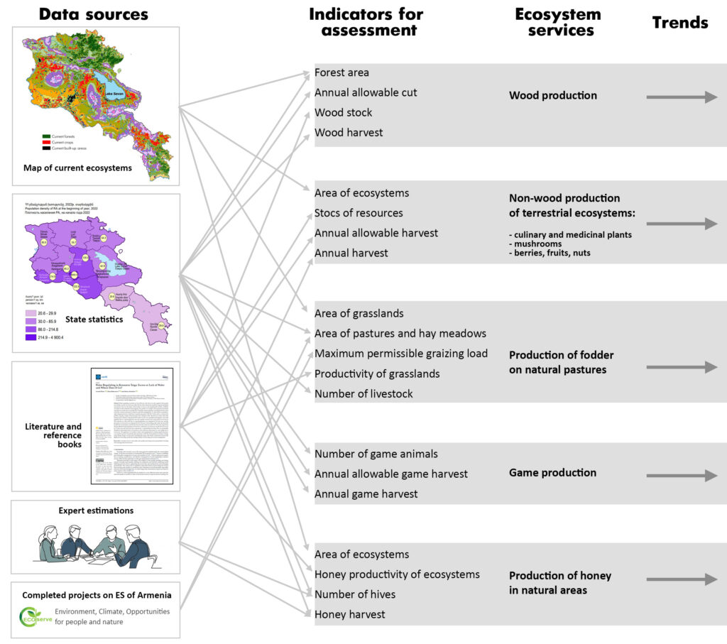
Scheme of testing available data for ES valuation and mapping
Indicators and data sources for testing available data for ES valuation and mapping
Provisioning ES: scheme of testing available data for ES valuation and mapping
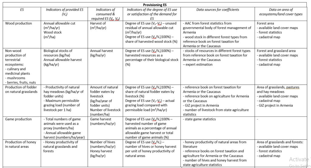
Indicators and data sources for testing available data for ES valuation and mapping
Cultural ES: scheme of testing available data for ES valuation and mapping
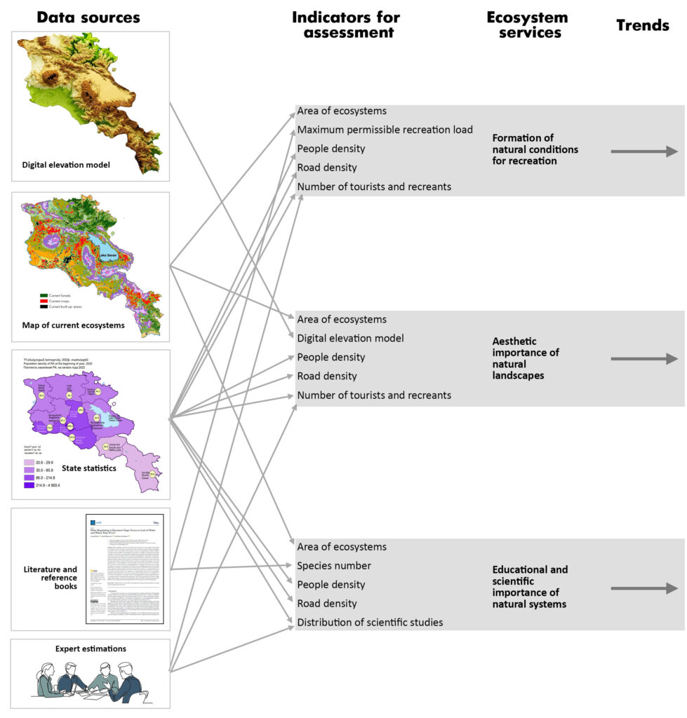
Indicators and data sources for testing available data for ES valuation and mapping
